Mapping where water comes from and where it goes
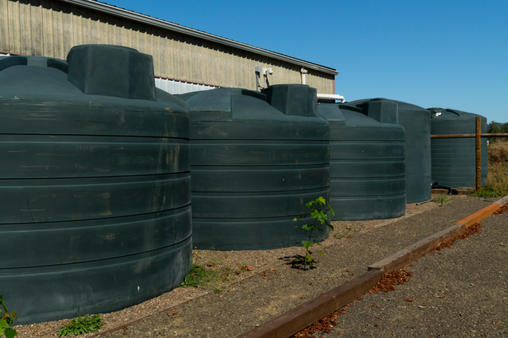
Tel-tvm’ (Siletz Tribal Farm) has 11 tanks to collect rainwater from their barn roofs. Read Tel-tvm’ Western Water Resilience Case Study (link opens a PDF) to learn more. Photo by Katrina Hudson
BY THE END OF THIS ARTICLE, YOU WILL BE ABLE TO…
- Map your farm’s water sources and loss pathways,
- Identify the constraints that shape your dry-season supply, and
- Locate your situation in the strategy table to identify where to focus your efforts first.
Water enters and leaves a farm in multiple ways, and each farm has its own mix of sources, timing, limitations, and losses. Understanding both sides of that equation — what comes in and when, and where it goes — shapes which water resilience strategies are available to you.
A farm with a reliable well and senior water rights is in a fundamentally different position than one relying on a low-yield well and rainfall only. This article helps you map that picture honestly so you can choose strategies that fit your specific constraints and opportunities rather than working from assumptions about what should be available.
SHARED VOCABULARY
Water rights: A legal entitlement to use water from a surface or groundwater source. In most Western states, water rights follow prior appropriation (‘first in time, first in right’) and may be restricted or cut off entirely during drought years by a water master. Having a well or stream on or near your property does not automatically mean you have the right to use that water for irrigation.
Exempt well: In Oregon and some other western states, certain low-volume wells are exempt from water rights permitting requirements and can be used for domestic purposes. Oregon HB3372 (effective January 1, 2026) expanded this to allow exempt domestic well water to irrigate small-scale commercial gardens up to one-half acre, permitting up to 3,000 gallons per day for commercial produce or flowers.
Evapotranspiration (ET): The combined loss of water from soil evaporation and plant transpiration. The largest single pathway by which water leaves most farms during the growing season. Driven by temperature, wind, solar radiation, and humidity. See Your Climate Story for how to assess ET demand on your specific site.
Infrastructure: The physical systems that move water from source to crop: wells, pumps, pipes, drip tape, tanks, cisterns, ponds. Infrastructure availability and condition directly affects how much of your available water you can actually deliver to fields — even abundant supply is limited by the capacity to move and store it.
Plant-available water: Water held in the soil that roots can actually extract. Determined by your soil’s texture, structure, and depth. See Your Soil Story for how to estimate this for each location on your farm.
ACTIVITY 1 – Map your water sources
List every water source you currently use or could potentially access. For each source, note the quantity or rate, any legal or physical limitations, and relevant seasonal timing. If you have questions about water quality, including concerns around contamination, salinity, or pathogen load, contact your local extension office or NRCS for testing resources. The filled out rows show an example farm. Add your own information in the blank rows below.
| Source | Quantity / rate | Limitation? | Additional notes |
|---|---|---|---|
| Avg. annual rainfall | 39.3 in | Drought timing | June–Sept: ~1 inch total |
| Stream / water rights | 0 | Junior water rights | Cut off June/July in drought years |
| Well | 2 gal/min | Tends to dry out by August | |
| Cisterns / tanks | 2,000 gal | Only enough to irrigate starts in the spring | |
| Municipal water | Expensive — emergency backup only | ||
After completing the table, consider:
- Which sources are unavailable or severely limited during your driest months?
- What is your realistic total water supply during the dry season?
- Do you have any backup sources if your primary source fails or is restricted?
ACTIVITY 2 – Map how water leaves your farm
Understanding losses is as important as mapping sources. For each pathway below, estimate its significance on your farm, note what is driving it, and record any practices you already have in place to reduce it.
Deeper reading: The site factors publication covers evapotranspiration, vapor pressure deficit, and wind in detail. If you’d like more context for estimating ET-driven losses before completing this table, read Section 1 of Understanding and Evaluating Site Factors Related to Dry-Farmed Vegetable Productivity first.
| Loss pathway | Significance (high / med / low) | Driving factors on your site | Practices already in place to reduce this |
|---|---|---|---|
| Evaporation (‘non-productive’ loss from bare soil) | |||
| Transpiration (‘productive’ water used by crops) | |||
| Runoff (rain or irrigation leaving the field) | |||
| Deep drainage / leaching below root zone | |||
| Distribution losses (leaks, inefficient irrigation) |
After completing the table, consider:
- Which loss pathway has the greatest impact during your dry season?
- Where are the highest-leverage opportunities to reduce losses — through mulch, cover crops, irrigation system improvements, or windbreaks?
- If you could address one loss pathway this season, which would have the most impact on your overall water budget?
ACTIVITY 3 – Assess your water system’s flexibility
A resilient water system has options — backup sources, ways to reduce demand, and infrastructure to store what falls. For each question below, note your current situation and any opportunities you see
| Flexibility question | Your current situation | Opportunities to improve |
|---|---|---|
| Do you have backup water sources if your primary source fails or is restricted? | ||
| Can you shift crops or planting dates to reduce water demand during the driest period? | ||
| Can you capture and store more of the water that already falls on your land? |
SEE IT IN CONTEXT – Section 4: Case Studies
One example in Section 4 is Tel-Tvm’ (Siletz Tribal Farm), which collects rainwater from barn roofs into 11 tanks. Their story shows what creative water storage looks like in practice.
The case studies in Section 4 show how growers in specific contexts have applied the tools in this article. They’re illustrations, not blueprints — and you may not see your climate, your scale, or your crop mix reflected in what’s currently available. Each farm is unique. If your context isn’t reflected yet, your experience is what this community needs. We’re actively building more examples. Email us at info@dryfarming.org.
From your water map to strategy
Look at your completed water sources and losses tables. Find the row or rows that most closely describe what you see. Check the box next to each one that applies — if more than one fits, they likely work together.
| My water map shows… | ✓ | Strategy areas worth exploring first |
|---|---|---|
| Rainfall is the primary water source; the dry season runs 3 or more months with little or no supplemental irrigation available | □ | Dry farming as a primary strategy; deep soil building to maximize stored water; pre-season soil moisture banking; planting timing and variety selection to match crops to the available water window. |
| Irrigation supply is present but limited — well yield, tank capacity, or rights restrict how much I can put on in the dry season | □ | Soil moisture monitoring to irrigate only when needed; drip or subsurface irrigation to minimize losses; rainwater catchment to expand storage; cover crops and mulch to extend intervals between irrigations. |
| Water supply is relatively accessible, but soil dries quickly after rain or irrigation — water seems to leave faster than expected | □ | ET reduction first: mulch, windbreaks, shade structures, reduced bare soil. Irrigation timing and method improvements (early morning, drip over overhead). You may have more effective water than current losses suggest. |
| Flooding or waterlogging occurs in wet months, alongside water scarcity in the dry season | □ | Two-season management: drainage and infiltration work for the wet season; storage and retention for the dry season. Earthworks, bioswales, and catchment ponds can address both. Organic matter improves drainage in wet conditions and retention in dry ones. |
| Distribution system issues — leaks, pressure inconsistency, or uneven delivery to different parts of the farm | □ | System audit before other investments. Delivery losses may be the highest-leverage fix available. What reaches the crop matters more than what leaves the source. |
| No current irrigation infrastructure; rainfall-only system with uncertain storage capacity | □ | Start with the soil: AWHC assessment tells you how much winter rain your soil is already storing. From there, identify whether storage, infrastructure, or crop selection is the highest-priority investment. |
PUTTING IT INTO PRACTICE
- Which row in the table most closely matches your dry-season water situation?
- What is the single highest-significance loss pathway on your farm right now?
- What is your realistic total water supply during your two driest months?
Carry forward: If you’re working through the toolkit linearly, your dry season length and highest-ET area carry into Article 2 as context for mapping your water sources and losses.
RESOURCES
Stretching Water Resources in the Dry Season (link opens PDF file) — — Oregon State University Extension. Tools and strategies for extending water supply during the dry season. Direct complement to this article.
Water Calculators — — Oregon State University Extension. A collection of calculators for determining flow rates and other aspects of irrigation planning and water resource analyses.
Manage Flood-Prone Areas to Mitigate Excess Rainfall (link opens PDF file) — — Oregon State University Extension. This factsheet focuses on tools and strategies for dealing with excessive amounts of rainwater, particularly in areas prone to waterlogging.
Small Farm Water Access: HB3372 Explained — — Friends of Family Farmers. Overview of Oregon HB3372 (effective January 1, 2026), which expanded use of exempt domestic well water for small-scale commercial irrigation.
Water rights and water law: Using your irrigation water legally— — Oregon State University Extension.
OpenET — — Satellite-based evapotranspiration data by field. For growers who want a detailed look at ET demand on their specific ground.
Tel-Tvm’ Western Water Resilience Case Study — — DFI. How a Siletz Tribal Farm built a 11-tank rainwater collection system from barn roofs. An example of water infrastructure adapted to a specific site and community context.
Farming Off‑Grid: Building a Solar‑Powered Irrigation System — — Oregon State University Extension. How off-grid systems could open new doors for small farms.
DFI × OSU CRAFS · Water Resilience Toolkit · Grower Pathway